|
Historical Railway Photograph Gallery 2751-2800 |
|||||||||
|
Photos 2751-2800 |
|||||||||
| Photo | ELR | Branch | Subject | Location | M | C | Elev'n | Date | Time |
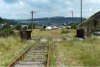
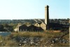 bpm02751.jpg |
BDL | Barry Docks-High level lines | View of the old Barry Railway Co's engine house | Footbridge at Barry Low Level Goods yard | |||||
 bpm02752.jpg |
BDL | Barry Docks-High level lines | Another view of the old Barry Railwy Co's engine house with the remodelled roadways in the foreground | Footbridge at Barry Low Level Goods yard | |||||
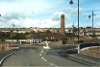
 bpm02753.jpg |
BDL | Barry Docks-High level lines | Year 2006-constructed new Entrepreneurial centre under final exterior dressing and situated alongside the old Barry Railway Co's engine house | Remodelled roadway south-east of former Barry Low Level goods yard | 2006 | ||||
 bpm02754.jpg |
BDL | Barry Docks-High level lines | The year-2006 constructed new Entrepreneurial centre under final exterior dressing and situated alongside the old Barry Railway Co's engine house | Remodelled roadway south-east of former Barry Low Level goods yard | 2006 | ||||
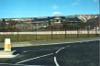
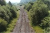
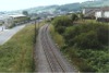
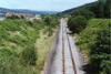
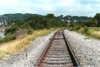 bpm02755.jpg |
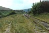
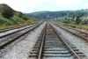
BAL | Bridgend & Abergwynfi | South elevation of single line approaching Tondu junction | South of Tondu junction and station | 2 | 39 | South | ||
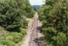
 bpm02756.jpg |
BAL | Bridgend & Abergwynfi | North elevation of single line south-east of Tondu junction. A new passenger halt was established just beyond the overbridge in the distance, to serve the new passenger service introduced in 1992 | North of Afon Llynfi underbridge | 2 | 33 | North | ||
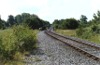
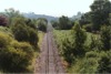
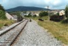
 bpm02757.jpg |
BAL | Bridgend & Abergwynfi | View looking towards Maesteg from Shwt Rd (Pontredu) road overbridge | No. 19 road overbridge, north of Coytrahen | 4 | 12 | South | ||
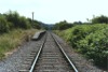
 bpm02758.jpg |
BAL | Bridgend & Abergwynfi | View looking towards Tondu from Shwt Rd (Pontredu) road overbridge | No. 19 road overbridge, north of Coytrahen | 4 | 12 | North | ||
 bpm02759.jpg |
BAL | Bridgend & Abergwynfi | View looking towards British Tissues paper mill (Now Georgia Pacific [2005]) The groundframe and works connection visible is now removed but just beyond is Brynllwyarch level crossing, at the 5-milepost, and used by the Company to access its water treatment plant on the right-hand side of the line | Gelli-Las Power station road overbridge, south of British Tissues factory. (Later Georgia Pacific) and north of former Llynfi power station site | 4 | 66 | South | ||
 bpm02760.jpg |
BAL | Bridgend & Abergwynfi | Looking south from Gelli Las power station road overbridge towards Tondu. The demolished power station stood on the left of the line | Gelli-L�s Power station road overbridge, south of British Tissues factory. (Later Georgia Pacific) and north of former Llynfi power station | 4 | 66 | North | ||
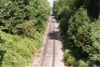
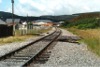
 bpm02761.jpg |
BAL | Bridgend & Abergwynfi | Looking north towards the site of the up platform at Llangynwyd station, the line then only being used for coal traffic. The up platform is not visible. By 2006 a re-opening of the station was being considered as the line had been re-opened to passengers in 1992. | No.28 Road overbridge south of Llangynwyd station site | 6 | 20.25 | South | ||
 bpm02762.jpg |
BAL | Bridgend & Abergwynfi | Looking south from road overbridge immediately south of former Llangynwyd station site. The line was re-laid during 2004 | No.28 Road overbridge south of Llangynwyd station site | 6 | 20.25 | North | ||
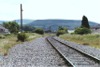
 bpm02763.jpg |
BAL | Bridgend & Abergwynfi | Looking north at B4282 Troedyrhiw road underbridge. The new single Garth platform halt opened in 1992 on the re-opening of the Maesteg passenger service, now lies on the left, beyond the bridge | No.33 Road underbridge at Garth (Formerly Troedrhiew Garth) | 6 | 79.75 | South | ||
 bpm02764.jpg |
BAL | Bridgend & Abergwynfi | Looking south at the then closed Troedrhiew Garth halt. The platform was subsequently removed and a new halt located to the north of the site, was opened upon the re-introduction of a Maesteg passenger service in 1992. The station name was shortened to Garth | Former Troedrhiew Garth halt immediately south of No.33 road underbridge, Garth | 6 | 79.75 | North | ||
 bpm02765.jpg |
BAL | Bridgend & Abergwynfi | Looking towards Maesteg from Ewenny Industrial Estate road overbridge. After the re-introduction of the Maesteg Passenger service in 1992, a new halt was located 8.5 chains north of the camera point | No.35A Road overbridge at Ewenny Industrial Estate between Garth and Maesteg | 7 | 47.5 | South | ||
 bpm02766.jpg |
BAL | Bridgend & Abergwynfi | Looking towards Garth from Ewenny Industrial Estate road overbridge. | No.35A Road overbridge at Ewenny Industrial Estate between Garth and Maesteg | 7 | 47.5 | North | ||
 bpm02767.jpg |
BAL | Bridgend & Abergwynfi | View of former 3-line rail overbridge south of Maesteg station. The Bridge location is 7M-74.5C | No.38, Castle St road underbridge, Maesteg | 7 | 73 | South | ||
 bpm02768.jpg |
BAL | Bridgend & Abergwynfi | Single line reverse curve south of original Maesteg station. The 1992 station is now sited to the left of the fence (See later record) | New Maesteg station site south of Somerfield supermarket and original station site (Castle St) | 8 | 07 | South | ||
 bpm02769.jpg |
BAL | Bridgend & Abergwynfi | Looking south-east along single line curve from just south of new Maesteg station site | Immediately south of new Maesteg station site (Castle St) | 8 | 06 | NW | ||
 bpm02770.jpg |
BAL | Bridgend & Abergwynfi | Looking towards Maesteg from Nantyffyllon long headshunt siding. In September 2006 the terminal telegraph pole was still standing but to the rear of the camera, a rail overbridge and the following embankment had been removed | Just south of Tywith/Coegnant Rd underbridge, Nantyffyllon | 9 | 07 | NW | ||
 bpm02771.jpg |
BAL | Bridgend & Abergwynfi | Looking towards the buffer stop at the curtailed line to Cymmer Afan. An inspection September 2006 showed the earthworks and bridge completely removed and the area partly built on | Just south of Tywith/Coegnant Rd underbridge, Nantyffyllon | 9 | 07 | South | ||
 bpm02772.jpg |
BAL | Bridgend & Abergwynfi | Looking towards Nantyffyllon from a point north of the former Llynfi junction. All that remained of this scene by 2006 was the trackbed.The Afon Llynfi underbridge with side railings is just visible beyond the second telegraph pole | South of the Afon Llynfi underbridge (No.42), Nantyffyllon | 8 | 71.5 | South | ||
 bpm02773.jpg |
BAL | Bridgend & Abergwynfi | Looking south towards Maesteg when coal traffic was still in operation. | South of the Afon Llynfi underbridge (No.42), Nantyffyllon | North | ||||
 bpm02774.jpg |
BAL | Bridgend & Abergwynfi | Looking south towards Maesteg when coal traffic was still in operation. The left-hand turnout to the incline, led to the British Coal Maesteg Central Washery and once formed a link to the Port Talbot-Pontyrhyl line at Cwmdu, Maesteg. Note that the nearest switch is spring-loaded, set for the crossover | Llynfi North groundframe | 8 | 59 | North | 24-Jun-89 | |
 bpm02775.jpg |
BAL | Bridgend & Abergwynfi | Looking north towards Nantyffyllon and the little-used sidings complex. A groundframe (off picture on the left) operated the points still used at the time for traffic to & from Maesteg Central Washery and a run-around facility was necessary to get the diesel locomotive at the right end of the trainload | Llynfi North groundframe | 8 | 58 | SE | 24-Jun-89 | |
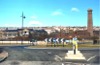
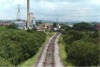
 bpm02776.jpg |
VON | Swansea Docks & Neath Riverside | Looking towards Neath & Brecon junction from a road overbridge immediately north of Neath Riverside signal box. The VON junction mileage is 41M-17C, equivalent to 0M-01C on the NAB, the latter diverging left. The then mothballed VON line to Cwmgwrach runs to the right. | Neath & Brecon junction, Neath | 41 | 20.5 | SW | 24-Jun-89 | 13.23 |
 bpm02777.jpg |
VON | Swansea Docks & Neath Riverside | Looking south from an overbridge immediately north of Neath Riverside signal box and former station | Neath & Brecon Jct signal box at former Neath Riverside station | 41 | 20.5 | North | 24-Jun-89 | 13.24 |
 bpm02778.jpg |
VON | Swansea Docks & Neath Riverside | Looking towards Neath Riverside signal box and former station showing a recently-re-ballasted and realigned single line | Out-of-use road overbridge south of former Neath Riverside station | South | 24-Jun-89 | 13.26 | ||
 bpm02779.jpg |
VON | Swansea Docks & Neath Riverside | The north end of the passing loop south of former Neath Riverside station | Footbridge over Vale of Neath line south of former Neath Riverside station | 41 | 26 | North | 24-Jun-89 | 13.31� |
 bpm02780.jpg |
NAB | Neath & Brecon (Free St) | Adjacent to former Penscynor halt | 1 | 29 | South | 24-Jun-89 | 13.40 | |
 bpm02781.jpg |
NAB | Neath & Brecon (Free St) | Rail overbridge over former Neath & Merthyr A465 trunk road | North | 24-Jun-89 | 13.40 | |||
 bpm02782.jpg |
NAB | Neath & Brecon (Free St) | Cwmgwrach | Former A465 Neath-Merthyr trunk road underbridge south-west of site of Penscynor halt | 1 | 29 | 24-Jun-89 | ||
 bpm02783.jpg |
VON | Neath (General) & Pontypool Road | Looking south-west from the road overbridge at the former Resolven station where the down platform structure was still in position . The line was in mothball at the time but was later re-opened to Ryan's coal complex at Cwmgwrach, Glyn Neath | B4434 Road overbridge north of Resolven station site | 35 | 21.75 | NE | 24-Jun-89 | 14.15 |
 bpm02784.jpg |
VON | Neath (General) & Pontypool Road | Looking north-east from the road just NE of the former Resolven station. The line was then in mothball but was later re-opened for coal extraction from Ryan's complex at Cwmgwrach | B4434 Road overbridge north of Resolven station site | 35 | 21.75 | SW | 24-Jun-89 | 14.17 |
 bpm02785.jpg |
VON | Neath (General) & Pontypool Road | Looking south-west towards Neath from the mothballed line between Neath and Cwmgwrach, since re-opened for the Ryan coal complex at Cwmgwrach, Glyn Neath | Between Clyne and Tonna | NE | ||||
 bpm02786.jpg |
JER | Jersey Marine | The double line Jersey Marine branch approaching Jersey Marine Jct North | Just south-east of Jersey Marine Jct North | 1 | 45 | SE | 05-Sep-89 | 12.08 |
 bpm02787.jpg |
JER | Jersey Marine | The double line Jersey Marine branch approaching Jersey Marine Jct North | South-east of Jersey Marine Jct North | 1 | 35 | South | 05-Sep-89 | 12.12� |
 bpm02788.jpg |
JER | Jersey Marine | Looking southwards along the Jersey Marine branch towards Jersey Marine Jct South, from an access road overbridge in the Llandarcy area | Between Jersey Marine North & South junctions | 1 | 55 | North | 05-Sep-89 | 12.16 |
 bpm02789.jpg |
JER | Jersey Marine | Looking northwards along the Jersey Marine branch towards Skewen from an access road overbridge in the Llandarcy area | 1 | 55 | South | 05-Sep-89 | 12.16� | |
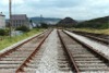
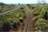
 bpm02790.jpg |
VON | Neath (Riverside) & Swansea Docks | Looking north towards Skewen and Neath Riverside along the single line Vale of Neath branch | M4 Road overbridge | 43 | 59.5 | South | 05-Sep-89 | 12.21 |
 bpm02791.jpg |
VON | Neath (Riverside) & Swansea Docks | Looking southwards along the single line Vale of Neath branch between Skewen and Jersey Marine Jct South | M4 Road overbridge | 43 | 59.5 | North | 05-Sep-89 | 12.21 |
 bpm02792.jpg |
JER | Jersey Marine | The Jersey Marine branch looking southwards towards Jersey Marine Jct South, from access road overbridge just south of the M4 motorway overbridge, Llandarcy | Private road overbridge near former BP Llandarcy Tennent Canal pump house | 1 | 66 | North | 05-Sep-89 | 12.24� |
 bpm02793.jpg |
JER | Jersey Marine | Up & down little-used lines between Jersey Marine Jct South and North. The skew bridge carries the M4 motorway | Adjacent to former BP Llandarcy Tennent canal pump house | 1 | 65 | South | 05-Sep-89 | 12.26 |
 bpm02794.jpg |
SWM RSB |
Severn Tunnel Jct & Fishguard
Harbour Rhondda & Swansea Bay |
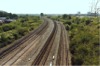
Looking south towards Baglan with the down through freight lines on the right | Road access overbridge to industrial area in former Briton Ferry dockland | 205 | 64 | North | 06-Sep-89 | 12.12 |
 bpm02795.jpg |
SWM RSB BAN |
Severn Tunnel Jct & Fishguard
Harbour Rhondda & Swansea Bay Baglan |
Looking south towards Baglan with the siding to Baglan Bay chemical complex on the right and the South Wales main line and down loop on the left | Road access overbridge to industrial area in former Briton Ferry dockland |
205 17 0 |
64 09 10 |
North | 06-Sep-89 | 12.12� |
 bpm02796.jpg |
SWM RSB BAN |
Severn Tunnel Jct & Fishguard
Harbour Rhondda & Swansea Bay Baglan |
Looking towards Neath and the A48 Road overbridge which spans the river Neath to the left of the scene. The single line on the left led to the former BP Chemicals Baglan Bay complex. The next line to the right was part of the R &SB line to Swansea | Road access overbridge to industrial area in former Briton Ferry dockland |
205 17 0 |
64 09 10 |
South | 06-Sep-89 | 12.12� |
 bpm02797.jpg |
SWM RSB BAN |
Severn Tunnel Jct & Fishguard
Harbour Rhondda & Swansea Bay Baglan |
Looking towards Neath and the A48 Road overbridge which spans the river Neath to the left of the scene. The single line on the left led to the former BP Chemicals Baglan Bay complex. The next line to the right was part of the R&SB line to Swansea. The up & down South Wales Main lines are on the right | Road access overbridge to industrial area in former Briton Ferry dockland |
205 17 0 |
64 09 10 |
South | 06-Sep-89 | 12.13 |
 bpm02798.jpg |
SWM RSB |
Severn Tunnel Jct & Fishguard
Harbour Rhondda & Swansea Bay |
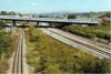
Looking towards Neath and Court Sart junction. The up R&SB flying loop line is on the right and the skew arched bridge was part of the South Wales Mineral Railway's single line to Ton Mawr via the Ynysmaerdy rope incline | Ynysmaerdy Rd overbridge south of Court Sart junction |
206 17 |
40 67 |
South | 06-Sep-89 | 12.23 |
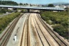
 bpm02799.jpg |
SWM RSB |
Severn Tunnel Jct & Fishguard
Harbour Rhondda & Swansea Bay |
Looking along the South Wales Main up & down lines east of Court Sart junction. Briton Ferry sidings fan culminates at the single line outlet in the distance where Court Sart junction routes traffic towards Neath and Swansea straight on and to the left, to Swansea Docks via Dynevor junction and Jersey Marine or to Llanelli via the Swansea District line, taking in the river Neath swingbridge and Felin Fr�n. The up flying loop from the SDI route is hidden on the right and passes under the skew arched bridge | Ynysmaerdy Rd overbridge south of Court Sart junction |
206 17 |
40 67 |
South | 06-Sep-89 | 12.23� |
 bpm02800.jpg |
SWM RSB |
Severn Tunnel Jct & Fishguard
Harbour Rhondda & Swansea Bay |
Looking towards Court Sart junction at the culmination of the Briton Ferry sidings fan and down goods (former R&SB) line | Ynysmaerdy Rd overbridge south of Court Sart junction |
206 17 |
40 67 |
South | 06-Sep-89 | 12.24 |
|
Photos 2751-2800 |
|||||||||
|
Date Last Revised:December 10, 2009 |
|||||||||