|
Historical Railway Photograph Gallery 2351-2400 |
|||||||||
|
Photos 2351-2400 |
|||||||||
| Photo | ELR | Branch | Subject | Location | M | C | Elev'n | Date | Time |
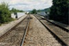
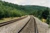
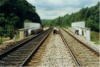
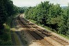
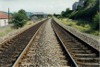
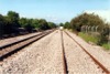
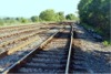
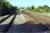
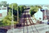
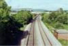
 bpm02351.jpg |
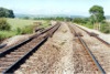
CAR | Cardiff (Stonefield Jct) & Rhymney | Up & down main line at Energlyn north of Caerphilly. The right-hand embankment once carried an interchange link between the Rhymney Railway and the Barry Railway lines to the Llanbradach viaduct | Energlyn | 9 | 35 | NW | 17-Aug-91 | 11.40 |
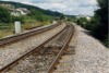
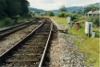
 bpm02352.jpg |
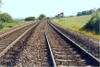
CAR | Cardiff (Stonefield Jct) & Rhymney | Up & down main lines at North Caerphilly bypass road underbridge | Approaching Energlyn | 9 | 78 | NW | 17-Aug-91 | 11.48 |
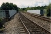
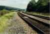
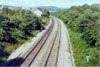
 bpm02353.jpg |
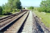
CAR | Cardiff (Stonefield Jct) & Rhymney | Breather in down main near Energlyn. In the distance can be seen a remaining arched pier which once carried the Barry Railway's Llanbradach viaduct | North of Aber Junction | 9 | 58 | SE | 17-Aug-91 | 11.43� |
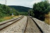
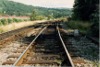
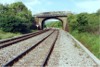
 bpm02354.jpg |
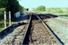
CAR | Cardiff (Stonefield Jct) & Rhymney | Up & down main lines at Caerphilly north-west bypass road underbridge | Approaching Energlyn | 10 | 01.5 | South | 17-Aug-91 | 11.48 |
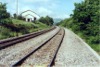
 bpm02355.jpg |
CAR | Cardiff (Stonefield Jct) & Rhymney | Looking north-west towards two of the remaining piers of the former Llanbradach viaduct of the Barry Railway which passed over the Cardiff and Rhymney lines | Just south of former Llanbradach viaduct | 10 | 13 | SE | 17-Aug-91 | 11.51� |
 bpm02356.jpg |
CAR | Cardiff (Stonefield Jct) & Rhymney | Up & down main lines just north of former Barry Railway Llanbradach viaduct, | Energlyn | 10 | 19.5 | South | 17-Aug-91 | 12.05 |
 bpm02357.jpg |
CAR | Cardiff (Stonefield Jct) & Rhymney | Up & down main lines just north of former Barry Railway, Llanbradach viaduct, south of Llanbradach. | Energlyn | 10 | 23 | West | 17-Aug-91 | 12.07 |
 bpm02358.jpg |
CAR | Cardiff (Stonefield Jct) & Rhymney | Portable magnet for ATC, placed for a temporary speed restriction in the vicinity of former Barry Railway, Llanbradach viaduct, north of Caerphilly | Energlyn | 10 | 43 | West | 17-Aug-91 | 12.11 |
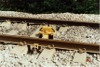
 bpm02359.jpg |
CAR | Cardiff (Stonefield Jct) & Rhymney | View of up & down main lines south of Llanbradach halt | Between Energlyn and Llanbradach | 10 | 45 | South | 17-Aug-91 | 12.13 |
 bpm02360.jpg |
CAR | Cardiff (Stonefield Jct) & Rhymney | View of up & down main lines south of Power Station road underbridge, Upper Boat | Tonteg Road underbridge between Upper Boat and Tonteg | NW | 14.24 | |||
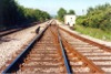
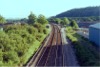
 bpm02361.jpg |
CAM | Cardiff (Bute Rd) & Merthyr | Up & down main lines at road underbridge near former Upper Boat Power Station site (South of former Maesmawr signal box) | Tonteg Road underbridge between Upper Boat and Tonteg | South | 14.24 | |||
 bpm02362.jpg |
CAM | Cardiff (Bute Rd) & Merthyr | Up & down main lines adjacent to now removed Maesmawr signal box. The previous up & down mineral line trackbed lies to the left of those lines still existing | South | |||||
 bpm02363.jpg |
CAM | Cardiff (Bute Rd) & Merthyr | Up & down main lines in vicinity of Maesmawr signal box with semaphore signalling. Signal box and semaphore signalling is now removed | NE | |||||
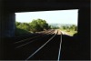
 bpm02364.jpg |
CAM | Cardiff (Bute Rd) & Merthyr | Up & down main lines in vicinity of Maesmawr signal box with semaphore signalling. Signal box and semaphore signalling is now removed | Pedestrian footbridge north of former Maesmawr signal box | 11 | 08 | NE | ||
 bpm02365.jpg |
CAM | Cardiff (Bute Rd) & Merthyr | Up & down main lines in vicinity of Maesmawr signal box with semaphore signalling. Signal box and semaphore signalling is now removed | Pedestrian footbridge north of former Maesmawr signal box | 11 | 08 | SW | ||
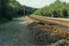
 bpm02366.jpg |
CAM | Cardiff (Bute Rd) & Merthyr | Out of use and partly buried former incline connecting Caerphilly & Pontypridd lines to the former Treforest industrial estate sidings and Upper Boat power station | Adjacent to Maesmawr signal box and to the north and at a lower level | SE | ||||
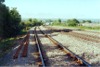
 bpm02367.jpg |
CAM | Cardiff (Bute Rd) & Merthyr | Up & down main lines at Maesmawr signal box. The trackbed devoid of track carried the former up & down relief lines and the signal box has been transferred to the Dean forest Railway | Maesmawr signal box | 10 | 47 | NW | ||
 bpm02368.jpg |
CAM | Cardiff (Bute Rd) & Merthyr | Up & down main lines north of Treforest station | North of Treforest station | SE | ||||
 bpm02369.jpg |
CAM | Cardiff (Bute Rd) & Merthyr | Up & down main lines north of Treforest station | North of Treforest station | NW | ||||
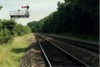
 bpm02370.jpg |
CAM | Cardiff (Bute Rd) & Merthyr | Trailing crossover in down main, south of Pontypridd station showing point heating propane cylinder installation | South of Pontypridd station | East | ||||
 bpm02371.jpg |
CAM | Cardiff (Bute Rd) & Merthyr | Up & down main lines showing "breather" in down main line | Between Treforest & Pontypridd stations | NW | ||||
 bpm02372.jpg |
CAM | Cardiff (Bute Rd) & Merthyr | Trailing crossover south of former PC&N junction | South of Pontypridd | West | ||||
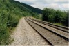
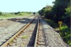
 bpm02373.jpg |
SWM | Severn Tunnel Jct & Fishguard Harbour | Down loop line at Tremains east | Tremains east | West | ||||
 bpm02374.jpg |
SWM | Severn Tunnel Jct & Fishguard Harbour | Lead to down loop line, Tremains east | Tremains east | West | ||||
 bpm02375.jpg |
SWM | Severn Tunnel Jct & Fishguard Harbour | Severn Tunnel Jct & Fishguard Harbour | North of Coychurch | SW | ||||
 bpm02376.jpg |
SWM | Severn Tunnel Jct & Fishguard Harbour | Severn Tunnel Jct & Fishguard Harbour | North of Coychurch | NE | ||||
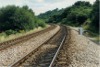
 bpm02377.jpg |
SWM | Severn Tunnel Jct & Fishguard Harbour | Up & down superelevated main line | Accommodation underbridge between Pencoed & Coychurch | SW | ||||
 bpm02378.jpg |
SWM | Severn Tunnel Jct & Fishguard Harbour | Up & down superelevated main line | Just south of accommodation underbridge between Pencoed & Coychurch | NE | ||||
 bpm02379.jpg |
SWM | Severn Tunnel Jct & Fishguard Harbour | Superelevated track south of entrance to up goods loop south of Pencoed . The M4 motorway overbridge is seen in the background | Just south of up goods loop entrance, Pencoed | SW | ||||
 bpm02380.jpg |
SWM | Severn Tunnel Jct & Fishguard Harbour | Superelevated track at entrance to up goods loop south of Pencoed | Lead to up goods loop, Pencoed | SW | ||||
 bpm02381.jpg |
SWM | Severn Tunnel Jct & Fishguard Harbour | Catch points in up goods loop, Pencoed | Up goods loop, Pencoed | NE | ||||
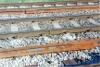 bpm02382.jpg |
SWM | Severn Tunnel Jct & Fishguard Harbour | New "breather" half-sets lying each side of the up main, south of Pencoed, awaiting installation in track. The nearest line is the up goods loop | Up goods loop, Pencoed | West | ||||
 bpm02383.jpg |
SWM | Severn Tunnel Jct & Fishguard Harbour | View of up & down main and up relief goods loop (left) at location of M4 motorway overbridge, south of Pencoed | M4 motorway overbridge, south of Pencoed | South | ||||
 bpm02384.jpg |
SWM | Severn Tunnel Jct & Fishguard Harbour | Elevated view of up & down main and up relief goods loop (left) at location of M4 motorway overbridge, south of Pencoed | M4 motorway overbridge, south of Pencoed | SW | ||||
 bpm02385.jpg |
SWM | Severn Tunnel Jct & Fishguard Harbour | View of up & down main and up relief goods loop (left) just south of Pencoed level crossing and footbridge. | South of Pencoed level crossing | South | ||||
 bpm02386.jpg |
SWM | Severn Tunnel Jct & Fishguard Harbour | View of up & down main and up relief goods loop (right) just south of Pencoed level crossing and footbridge. | Adjacent to 187 milepost and north of the M4 motorway overbridge south of Pencoed | 186 | 79.75 | North | ||
 bpm02387.jpg |
SWM | Severn Tunnel Jct & Fishguard Harbour | View of up & down main and up relief goods loop (left) just south of Pencoed level crossing | Adjacent to 187 milepost and north of the M4 motorway overbridge south of Pencoed | 187 | 1.25 | South | ||
 bpm02388.jpg |
SWM | Severn Tunnel Jct & Fishguard Harbour | View of up & down main lines at Pencoed level crossing. Later a halt was reinstated to serve the locality, the up platform being placed beyond the level crossing on the left | Footbridge at Pencoed level crossing | 186 | 55.5 | South | ||
 bpm02389.jpg |
SWM | Severn Tunnel Jct & Fishguard Harbour | View of up & down main lines at Pencoed level crossing. Later a halt was reinstated to serve the locality, the up platform being placed beyond the level crossing on the left | Footbridge at Pencoed level crossing | 186 | 55.5 | South | ||
 bpm02390.jpg |
SWM | Severn Tunnel Jct & Fishguard Harbour | View of up & down main lines at Pencoed level crossing. Later a halt was reinstated to serve the locality, the down platform being placed on the left, beyond the camera point | Footbridge at Pencoed level crossing | 186 | 55.5 | North | ||
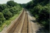
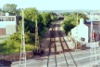
 bpm02391.jpg |
SWM | Severn Tunnel Jct & Fishguard Harbour | View of up & down main lines north of Pencoed level crossing | North of Pencoed level crossing and up platform | South | ||||
 bpm02392.jpg |
SWM | Severn Tunnel Jct & Fishguard Harbour | View of up & down main lines north of Pencoed level crossing. The footbridge at Pencoed level crossing is visible in the distance | North of Pencoed level crossing and up platform | North | ||||
 bpm02393.jpg |
SWM | Severn Tunnel Jct & Fishguard Harbour | View of up & down main lines north of Pencoed . To serve a northerly bypass to Pencoed, the new road overbridge visible, was constructed, linking the A473 (out of picture on right) with the B4280 to Bryncethin | North of Pencoed | South | ||||
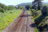
 bpm02394.jpg |
SWM | Severn Tunnel Jct & Fishguard Harbour | View of up & down main lines south of Brynna between Llanharan and Pencoed (and south of the now closed Bryn-y-gwynon level crossing) | Road overbridge (now closed to traffic) south of Bryn-y-Gwynon level crossing | South | ||||
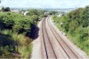
 bpm02395.jpg |
SWM | Severn Tunnel Jct & Fishguard Harbour | View of up & down main lines south of the now closed Bryn-y-Gwynon level crossing. The overbridge carried an unclassified road from Brynna to Pencoed but became redundant upon the construction of the new overbridge shown in frame bpm02393.jpg | Road overbridge (now closed to traffic) south of Bryn-y-Gwynon level crossing | South | ||||
 bpm02396.jpg |
SWM | Severn Tunnel Jct & Fishguard Harbour | View of up & down main lines south of the now closed Bryn-y-Gwynon level crossing. | South of Bryn-y-Gwynon level crossing | South | ||||
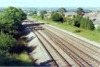
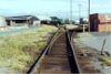 bpm02397.jpg |
CCS | Canton Fuel Sidings | View from headshunt to fuel sidings at Canton DMU dep�t | Cardiff Canton fuel sidings | West | ||||
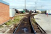 bpm02398.jpg |
CCS | Canton Fuel Sidings | View looking east towards fuel sidings and Canton DMU maintenance dep�t | Cardiff Canton former HST spur | West | ||||
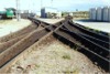 bpm02399.jpg |
CCS | Canton Fuel Sidings | Symmetrical geometry in the form of a scissors facility with fixed diamond (in effect, an outside double-slip) all in flat-bottomed rail | Cardiff Canton carriage shed sidings | West | ||||
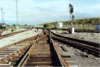 bpm02400.jpg |
RAD | Radyr | Tandem turnout adjacent to signal C307, Canton sidings | East end of Ninian Park halt | West | ||||
|
Photos 2351-2400 |
|||||||||
|
Date Last Revised:December 02, 2009 |
|||||||||