|
Historical Railway Photograph Gallery 701-750 |
|||||||||
| 651-700 <- |
Photos 701-750 |
-> 751-800 | |||||||
| Photo | ELR | Branch | Subject | Location | M | C | Elev'n | Date | Time |
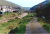
 bpm00701.jpg |
CTD PRS |
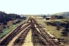
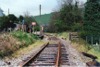
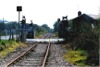
Cadoxton South & Trehafod Jct and Penrhos | Abandoned trackwork at Tynycaeau junction. The farthest junction leading to the St. Fagans branch, was the true Tynycaeau junction, the nearest junction being listed as Penrhos Junction, not to be confused with Penrhos junction at the northern end of the former Barry Railway Co's lines | Tynycaeau junction | 5 | 59 | North | ||
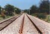
 bpm00702.jpg |
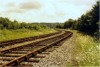
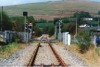
PRS | Penrhos | Abandoned double line on Penrhos branch, north of Tynycaeau junction | Peterston road underbridge | 6 | 9.5 | NE | ||
 bpm00703.jpg |
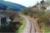
PRS | Penrhos | Abandoned double line on Penrhos branch, north of Tynycaeau junction | Peterston road underbridge | 6 | 9.5 | South | ||
 bpm00704.jpg |
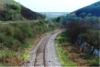
PRS | Penrhos | Abandoned double line showing series of overbridges between Rhydlafar and Walnut Tree tunnel | Pentyrch bank | 8 | 00 | SW | 10-Jul-64 | 15.24 |
 bpm00705.jpg |
PRS | Penrhos | View of Pentyrch cutting with farm access overbridges when line was in full use. Former Pentyrch signal box was located on the left just before the viaduct (Black & white record) | Pentyrch bank | 8 | 26 | SW | 1960 | |
 bpm00706.jpg |
PRS | Penrhos | View of Pentyrch cutting with farm access overbridges after line was abandoned | Pentyrch bank | 8 | 26 | SW | 10-Jul-64 | 15.32 |
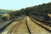
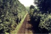
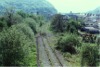
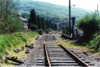
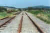
 bpm00707.jpg |
PRS | Penrhos | Abandoned double line between Tynycaeau junction and Walnut Tree West, at approach to Walnut tree tunnel. The south side of Steetley-Dolomite quarry is visible on the left. A fogman's hut still stands adjacent to the position of the former up distant signal | South-west of Morganstown and east of Pentyrch | 9 | 00 | SW | 10-Jul-64 | 15.33 |
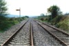
 bpm00708.jpg |
PRS | Penrhos | Looking towards Pentyrch & Tynycaeau, at lifted track south of Walnut Tree tunnel and south-west of Morganstown | South-west of Morganstown | NW | ||||
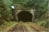
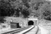 bpm00709.jpg |
PRS | Penrhos | Looking towards south portal of Walnut Tree tunnel when line was in full use (Black & white record) | Walnut Tree | 9 | 09 | SE | 1960 | |
 bpm00710.jpg |
PRS | Penrhos | Looking towards south portal of Walnut Tree tunnel after closure of line | Walnut Tree Tunnel, south east end | 9 | 09 | SE | 10-Jul-64 | 15.49 |
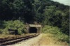
 bpm00711.jpg |
PRS | Penrhos | Looking towards south portal of Walnut Tree tunnel after closure and lifting of track | Walnut Tree Tunnel | 9 | 09 | SE | ||
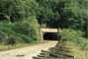
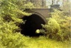
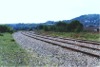
 bpm00712.jpg |
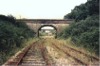
PRS | Penrhos | Track & overbridge at south portal of 490yd Walnut Tree tunnel (Limits, 9M-14C to 9M-36C) | Walnut Tree Tunnel | 9 | 13 | SE | 10-Jul-64 | 15.50 |
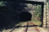
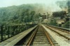
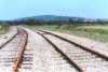
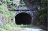 bpm00713.jpg |
PRS | Penrhos | South portal of 490-yard Walnut tree tunnel after lifting of track | Walnut Tree Tunnel | 9 | 13.5 | NW | ||
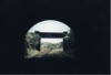 bpm00714.jpg |
PRS | Penrhos | South portal of Walnut Tree tunnel, viewed from inside, showing lane access overbridge to Steetley Doloma's quarry | Walnut Tree Tunnel | 9 | 15 | South | 10-Jul-64 | 15.51 |
 bpm00715.jpg |
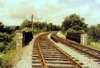
PRS | Penrhos | North portal of Walnut Tree tunnel viewed from inside and showing platelayers' cabin and Walnut Tree West signal box | Walnut Tree Tunnel | 9 | 34.5 | NW | 10-Jul-64 | 15.57 |
 bpm00716.jpg |
PRS | Penrhos | North-east elevation of north portal of Walnut Tree tunnel, showing down starting signal post with removed semaphore arm, seen lying on the ground. Sleeper buffer stops are visible as the line had been closed south of here | Walnut Tree tunnel, north end | 9 | 37 | NE | 10-Jul-64 | 16.00 |
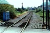
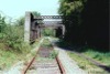
 bpm00717.jpg |
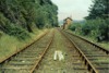
PRS | Penrhos | Walnut tree West signal box after closure of 'box and showing severed up line. Latterly, the line to here from Penrhos junction was worked as a long siding to the Steetley Doloma plant until final closure. | Walnut Tree West signal box | 9 | 39 | South | ||
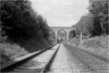
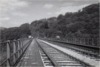
 bpm00718.jpg |
PRS | Penrhos | Walnut Tree viaduct showing track and bullhead guard-rail when only the up line was in use after branch had been reduced to "siding" status before final closure | Walnut Tree Viaduct | 9 | 59 | South | ||
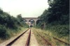
 bpm00719.jpg |
PRS | Penrhos | Walnut Tree viaduct with former Dolomite plant |
Walnut Tree Viaduct
|
9 | 59 | North | ||
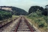
 bpm00720.jpg |
PRS | Penrhos | Walnut Tree viaduct showing track and bullhead guard-rail when only the up line was in full use (Black & white record) | Walnut Tree Viaduct | 9 | 59 | South | ||
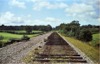
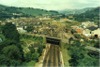 bpm00721.jpg |
CAM | Cardiff (Bute Road) & Merthyr | "Aerial" view of Walnut Tree junction and Taffs Well station, viewed from Walnut Tree viaduct. The first branch to the right is the start of the "big hill" to Penrhos junction and the Rhymney valley, the second to the right is the line to Nantgarw colliery, all of the latter now being removed. | Walnut Tree Viaduct | 9 | 59 | East | ||
 bpm00722.jpg |
PRS | Penrhos | Looking south from a lane overbridge over the deep cutting approaching the north end of Walnut tree viaduct. The cutting was subsequently backfilled and houses built just below the road level of the overbridge | North-east side of Walnut Tree viaduct | 10 | ~15 | North | ||
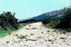
 bpm00723.jpg |
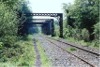
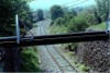
CRY | Coryton | North-West portal of now extinct 180-yard Tongwynlais tunnel. The tunnel was broken into and removed to absorb the new A470 dual carriageway and slip road into Tongwynlais and old A470 slip road, south-east bound from Taffs Well and Morganstown/Pentyrch cross-river/rail link. The old A470 road overbridge north of Tongwynlais can be seen through the far end of the bore | Opposite Ynys Fach yard (Tunnel limits were 4M-13C to 4M-21C) | 4 | 22 | NW | ||
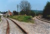
 bpm00724.jpg |
WNT | Walnut Tree junction & Penrhos junction | Trackbed on Walnut Tree to Penrhos junction section, photographed at wire fence boundary of late 90s park & ride car park at Taffs Well station. By March 2002, this was converted to a public right of way as part of the Taff Trail. | Walnut Tree junction on trackbed of Penrhos Bank | 11 | 76 | South | 07-May-89 | 11.30 |
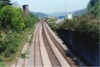 bpm00725.jpg |
CAM | Cardiff (Bute Road) & Merthyr | Up & down main & relief lines south of former Walnut Tree viaduct. (Relief lines rarely used at this time and later removed). The road overbridge in the distance shows the brick road sidewalls which replaced the earlier steel plated sides and the road sign shows that the through Taffs Well road had been re-designated the A4054 after the new A470 dual carriageway construction to Merthyr had been in use for some time | South East of Walnut Tree junction (Taffs Well) | ~6 | 75 | SE | 07-May-89 | 11.20 |
 bpm00726.jpg |
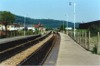
CAM | Cardiff (Bute Road) & Merthyr | View of north-west end of platform with truncated arm starting signal bracket and Nantgarw branch junction beyond | Taffs Well station | 7 | 23 | North | 07-May-89 | |
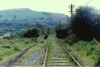
 bpm00727.jpg |
WNT | Walnut Tree junction & Penrhos junction | Trackbed of Walnut tree branch in vicinity of railway bridge over former Glamorganshire canal (to be verified!) | Taffs Well (Penrhos Bank, north-east of A470 (Rail overbridge) | ~11 | 56 | SW | 07-May-89 | 11.48 |
 bpm00728.jpg |
WNT | Walnut Tree junction & Penrhos junction | Abandoned advanced starting semaphore signal & trackbed north-east of A470 trunk road. This section was converted to a public right of way as part of the Taff Trail by March 2002. | Taffs Well (Penrhos Bank, north-east of A470 (Rail overbridge)) | ~11 | 56 | SE | 07-May-89 | 11.48 |
 bpm00729.jpg |
NAN CDF |
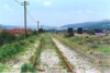
Walnut Tree junction & Nantgarw | Looking towards Nantgarw along the single line between Taffs Well and Glanyllyn after closure of the branch to Nantgarw colliery | Road overbridge at Glanyllyn | 5 | 27.5 | South | 07-May-89 | 11.59 |
 bpm00730.jpg |
NAN CDF |
Walnut Tree junction & Nantgarw | Looking towards Taffs Well along the single line between Taffs Well and Glanyllyn after closure of the branch to Nantgarw colliery | Road overbridge at Glanyllyn | 5 | 27.5 | North | 07-May-89 | 11.59 |
 bpm00731.jpg |
CAM NAN |
Cardiff (Bute Rd) & Merthyr / Nantgarw | Arrangement of level crossing showing anti-animal passage timbers and runaway catch-points in line beyond | Taffs Well CWS Level Crossing | 0 | 08 | NW | 07-May-89 | 12.03 |
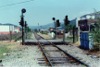 bpm00732.jpg |
NAN | Walnut Tree junction & Nantgarw | Arrangement of level crossing showing colour-light signals. Siding only used for City line trains terminating at Taffs Well at time of taking (All removed later) | Taffs Well CWS Level Crossing | 0 | 08 | SE | 07-May-89 | 12.03 |
 bpm00733.jpg |
NAN | Walnut Tree junction & Nantgarw | View of skew railway bridge over former A470 trunk road north-west of Glanyllyn, after closure of branch | A470 rail overbridge at Glanyllyn | ~1 | 00 | NW | 07-May-89 | 12.11 |
 bpm00734.jpg |
NAN | Walnut Tree junction & Nantgarw | View of skew railway bridge over former A470 trunk road north-west of Glanyllyn, after closure of branch | A470 rail overbridge at Glanyllyn | ~1 | 00 | SE | 07-May-89 | 12.11 |
 bpm00735.jpg |
NAN | Walnut Tree junction & Nantgarw | View looking towards Cardiff from embankment just beyond old A470 road underbridge at bottom end of Treforest Trading Esate. The signal box stood on the far side of the road bridge. The entire section in this area was removed by 1998 and the remaining embankment is now a walkers trail towards Glanyllyn | Adjacent to former Nantgarw colliery | ~1 | 50 | North | 07-May-89 | 12.15 |
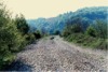
 bpm00736.jpg |
NAN | Walnut Tree junction & Nantgarw | The last remaining section of track after demolition and site clearance at former Nantgarw colliery | Adjacent to former Nantgarw colliery | ~1 | 50 | South | 07-May-89 | 12.15 |
 bpm00737.jpg |
BMZ | Blackmill | View of single line track looking towards former Brynmenyn junction. This is now a metalled cycleway and runs from Brynmenyn to Ogmore Vale | Abergarw A4065 road overbridge | ~0 | 75 | NE | 07-May-89 | 14.20 |
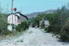
 bpm00738.jpg |
BMZ | Blackmill | View of accommodation crossing where the former double line section at Blackmill station precincts ran back into single line to Wyndham & Nantymoel. All converted into a cylceway in the late 1990's. (See April 2001 photo') | Blackmill accommodation crossing | ~2 | 68 | SW | 07-May-89 | 14.29 |
 bpm00739.jpg |
BMZ | Blackmill | View looking towards site of former Blackmill station from approximate site of double to single line junction (The double line section ran from the crossing point southwestwards towards the station and thence ran back into single line at 2M 49C). All converted into a cycle way in the late 1990's. (See April 2001 photo') | Blackmill accommodation crossing | ~2 | 69 | NE | 07-May-89 | 14.31 |
 bpm00740.jpg |
BMZ PBZ |
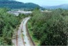
Blackmill Pencoed | View looking towards Tondu showing the, by then, out-of-use separated single lines to Ogmore & Garw Valleys. For about five years after this photo was taken, (1990-1995) the Garw valley line was reinstated for mountain coal spoil reclaim which relieved coal tips in the Blaengarw area and left the mountain in its original profile. | Just north-east of former Ynysawdre junction. Bryncethin | 0 | 25 | East | 07-May-89 | 14.55 |
 bpm00741.jpg |
BMZ PBZ |
Blackmill Pencoed | Separate single lines to Ogmore Vale line and Garw Valley line at site of former Ynysawdre junction from which point the single line to Llanharan West junction via Heol-y-Cyw and Wern Tarw ran. (The railway fence line is still clearly defined). The section from here to 4M-15C (Bryncethin junction) at Heol Laethog, was called the Pencoed Branch and from there to Llanharan West junction (0M-00C) was the Cardiff and Blackmill Branch. Note the expansion switch visible in the right continuous welded track. The left-hand track is normal bullhead line on timber sleepers | Former junction with Llanharan Branch (Brynmenyn) |
0 6 |
24 59 |
West | 07-May-89 | 14.55� |
 bpm00742.jpg |
BMZ | Blackmill | View looking north-east along separate single lines to Ogmore and Garw Valleys respectively. The divergence in the distance was the site of the former Brynmenyn station and the right line has now been converted to a cycleway to Ogmore Vale | Brynmenyn | 0 | 40 | SW | 07-May-89 | 14.58 |
 bpm00743.jpg |
BMZ | Blackmill | View looking north-east along separate single lines to Ogmore and Garw Valleys respectively. The divergence in the distance was the site of the former Brynmenyn station and the right line has now bee converted to a cycleway to Ogmore Vale | South West of former Brynmenyn station & junction | ~0 | 50 | SW | 07-May-89 | 15.02 |
 bpm00744.jpg |
BMZ | Blackmill | View looking south-west along separate single lines to Ogmore and Garw Valleys from Tondu respectively, showing lampless permanent caution semaphores for Tondu junction signal box. The left line (to Ogmore Vale) is now a cycleway from this area. Originally Brynmenyn Loop linked these lines with the Pencoed branch so that traffic could run to Cardiff without passing through Tondu and Bridgend but that loop was severed in 1940 | Former Brynmenyn junction | ~0 | 55 | NE | 07-May-89 | 15.04 |
 bpm00745.jpg |
OGM GAW |
Tondu & Margam junction & Blaengarw/Nantymoel | View at divergence of Ogmore and Gawr Valley lines at site of former Brynmenyn station. The right-hand line is now a cycleway and runs to Caedu signal box site (4M-78C) | Brynmenyn junction (0M-04C) & former station (0M 59C) | 0 | 04 | SW | 07-May-89 | 15.06 |
 bpm00746.jpg |
GAW | Tondu & Margam junction & Blaengarw | Single line level crossing with control lights and timber anti-cattle panels. | Llangeinor Level Crossing (2M-02C true) | 2 | 03 | NW | 07-May-89 | 15.20 |
 bpm00747.jpg |
GAW | Tondu & Margam junction & Blaengarw | Single line level crossing with control lights and timber anti-cattle panels. An expansion switch is visible at the end of a continuous welded track section, in the foreground. | Llangeinor Level Crossing (2M-20C true) | 2 | 03 | NE | 07-May-89 | 15.21 |
 bpm00748.jpg |
GAW | Tondu & Margam junction & Blaengarw | Single line curve as viewed from road overbridge south of former Pontyrhyl junction. The embankment which carried the Port Talbot Railway single line from Maesteg to Pontyrhyl junction is just visible above the roof-line of the house. The line was lifted at this point and seen as a tarmac cycleway in December 2005 and the bridge from where this original shot was taken had also been replaced | Road overbridge between Llangeinor & Pontyrhyl, off A4064 road to Blaengarw | 2 | 60 | SE | 07-May-89 | 15.25 |
 bpm00749.jpg |
GAW | Tondu & Margam junction & Blaengarw | View looking towards Llangeinor showing single line curve,. In December 2005 this sectio was seen to be lifted and converted to a cycleway. | Between Llangeinor & Pontyrhyl | 2 | 60 | NW | 07-May-89 | 15.25 |
 bpm00750.jpg |
GAW | Tondu & Margam junction & Blaengarw | Single line reverse curve after recent reballasting. Line was out-of-use at time of photograph but was reinstated for almost five years (1990-1995) to carry reclaim coal traffic from Blaengarw colliery tips. The former passenger station which had staggered platforms was located here, left side of scene. | Pontyrhyl | 3 | 20 | NW | 07-May-89 | 15.30 |
| 651-700 <- |
Photos 701-750 |
-> 751-800 | |||||||
|
Date Last Revised:November 30, 2009 |
|||||||||