|
Historical Railway Photograph Gallery 1401-1450 |
|||||||||
|
Photos 1401-1450 |
|||||||||
| Photo | ELR | Branch | Subject | Location | M | C | Elev'n | Date | Time |
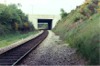
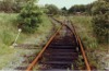
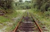
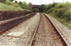
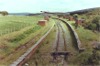
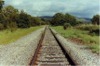
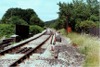
 bpm01401.jpg |
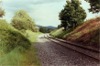
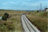
CAM | Cardiff (Bute Road) & Merthyr | Superelevated single line looking towards the deep cutting on the approach to Quakers Yard viaduct | Just south of new A470/A472 road cross-link overbridge north-east of Abercynon | 17 | 8.5 | South | 13-May-90 | 16.42 |
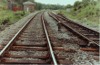
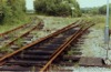
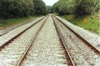
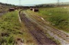
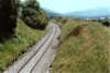
 bpm01402.jpg |
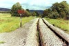
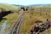
CAM | Cardiff (Bute Road) & Merthyr | Superelevated single line looking towards the deep cutting on the approach to Quakers Yard viaduct. The concrete side wall on the left is part of the support for the commencement of the newer A470 Merthyr trunk road, established on the left side of the River Taff valley | Just north of new A470/A472 road cross-link overbridge south-west of Quakers' Yard | 17 | 27 | SE | 13-May-90 | 16.48 |
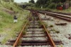
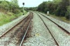
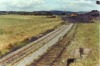
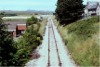
 bpm01403.jpg |
CAM | Cardiff (Bute Road) & Merthyr | Superelevated single line looking towards part of the re-modelled A470 road interchange west of Fiddlers Elbow and north-east of Abercynon | A470/A472 road cross-link overbridge north-east of Abercynon | 17 | 14 | South | 13-May-90 | 16.49 |
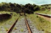
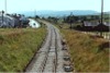
 bpm01404.jpg |
SDI | Court Sart junction & Morlais junction | The Swansea District line at the connection to the now cleared site of Velindre tinplate works. The junction has since been "plain-lined" | Llangyfelach, BSC Velindre inlet | 5 | 55 | East | 02-Jun-90 | 15.04 |
 bpm01405.jpg |
SDI | Court Sart junction & Morlais junction | The Swansea District line at the facing crossover and connection to the now cleared site of Velindre tinplate works. The junction has since been "plain-lined" | Llangyfelach, BSC Velindre inlet | 5 | 56 | West | 02-Jun-90 | 15.04 |
 bpm01406.jpg |
SDI | Court Sart junction & Morlais junction | The connection ftom the Swansea district line to the former Velindre tinplate works, showing the double-throw traps. The connection and signalling has since been removed | Llangyfelach, BSC Velindre inlet | 5 | 57 | NW | 02-Jun-90 | 15.06 |
 bpm01407.jpg |
SDI | Court Sart junction & Morlais junction | Looking west along the reception siding and run-around loop for the former British Steel's Velindre tinplate works, all now removed. There used to be a halt serving Llangyfelach, in this area | Access siding to BSC Velindre headshunt and works sidings | East | 02-Jun-90 | 15.09 | ||
 bpm01408.jpg |
SDI | Court Sart junction & Morlais junction | Looking east towards the Swansea District line from the BSC single line connection to Velindre tinplate works. All now removed | Access siding to BSC Velindre headshunt & yard | NW | 02-Jun-90 | 15.09 | ||
 bpm01409.jpg |
SDI | Court Sart junction & Morlais junction | Reception and run-around siding looking west towards headshunt within BSC Velindre tinplate works site. All now removed | West end (headshunt) siding to BSC Velindre yard | East | 02-Jun-90 | 15.14 | ||
 bpm01410.jpg |
SDI | Court Sart junction & Morlais junction | Looking east along the reception and run-around siding at BSC Velindre tinplate works site. The right hand line runs from a headshunt to rear of camera to fan out into the works sidings. All now removed and site completely cleared | Headshunt to BSC Velindre yard from access siding | NW | 02-Jun-90 | 15.14 | ||
 bpm01411.jpg |
SDI | Court Sart junction & Morlais junction | Looking east from an elevated position at the headshunt of BSC Velindre tinplate works complex. The Swansea District lines are justs visibleon the right in the distance. The complete works site and tracks were subsequently removed | Headshunt to BSC Velindre yard from access siding to BR | NW | 02-Jun-90 | 15.15 | ||
 bpm01412.jpg |
SDI | Court Sart junction & Morlais junction | The long headshunt siding at the BSC Velindre tinplate works complex. All later removed | Headshunt to BSC Velindre yard | NE | 02-Jun-90 | 15.15 | ||
 bpm01413.jpg |
SDI | Court Sart junction & Morlais junction | The BSC Velindre tinplate works sidings fan after closure. The complete site was later cleared | BSC Velindre yard | SW | 02-Jun-90 | 15.19 | ||
 bpm01414.jpg |
SDI | Court Sart junction & Morlais junction | Exit/entrance to sidings fan from the headshunt siding at BSC Velindre tinplate works site. All subsequently removed | BSC Velindre yard, south-west end (near headshunt) | NE | 02-Jun-90 | 15.19 | ||
 bpm01415.jpg |
SDI | Court Sart junction & Morlais junction | The up & down Swansea district lines at the 6 milepost. The headshunt siding to BSC Velindre tinplate works is just visible on a higher plain on the right | Alongside BSC Velindre yard, Llangyfelach west | 5 | 79.5 | East | 02-Jun-90 | 15.21 |
 bpm01416.jpg |
SDI | Court Sart junction & Morlais junction | Looking east from the 6-milepost alongside BSC Velindre tinplate works siding connection to the Swansea District line | Alongside BSC Velindre yard, Llangyfelach | 5 | 79.5 | West | 02-Jun-90 | 15.21 |
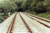
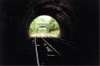 bpm01417.jpg |
SDI | Court Sart junction & Morlais junction | Looking towards Pontlliw from just inside the western end of Penllergaer tunnel | Penllergaer tunnel (north-west portal). From 6M-44.75C to 6M-57.75C, length 286 Yards | 6 | 57 | SE | 02-Jun-90 | 15.55 |
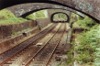
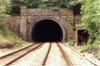 bpm01418.jpg |
SDI | Court Sart junction & Morlais junction | Looking south-east at the north-west portal of 284-yard Penllergaer tunnel | Penllergaer tunnel, north-west portal (From 6M-44.75C to 6M-57.75C) | 6 | 60 | NW | 02-Jun-90 | 15.57 |
 bpm01419.jpg |
SDI | Court Sart junction & Morlais junction | Looking towards Pontlliw from an overbridge just west of the north-west end of Penllergaer tunnel | Lane access overbridge west of Penllergaer tunnel | 6 | 61.5 | SE | 02-Jun-90 | 15.59 |
 bpm01420.jpg |
SDI | Court Sart junction & Morlais junction | Looking towards the north-west portal of Penllergaer tunnel from an access overbridge adjacent to the 6M-60C milepost | Penllergaer tunnel from north-west portal (From 6M-44.75C to 6M-57.75C). 287 yards long) | 6 | 61.5 | NW | 02-Jun-90 | 15.59 |
 bpm01421.jpg |
SDI | Court Sart junction & Morlais junction | Looking towards Llangyfelach from just inside the south-eastern portal of 287-yard Penllergaer tunnel | Penllergaer tunnel, south-east portal (From 6M-44.75C to 6M- 57.75C). | 6 | 46 | West | 02-Jun-90 | 16.04 |
 bpm01422.jpg |
SDI | Court Sart junction & Morlais junction | Looking towards the south-eastern portal of Penllergaer tunnel from a point just east of the 6M-40C milepost | Penllergaer tunnel approach | 6 | 39 | East | 02-Jun-90 | 16.07 |
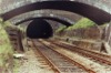
 bpm01423.jpg |
SWM | Severn Tunnel Jct & Fishguard Harbour | The north-west portal of 789-yard Cockett tunnel with the full bore visible | West portal of Cockett tunnel (From 216M- 27.75C to 216M-63.5C). | 216 | 64.5 | West | 02-Jun-90 | 16.45 |
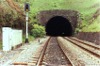
 bpm01424.jpg |
SWM | Severn Tunnel Jct & Fishguard Harbour | Looking towards the north-west portal of Cockett tunnel from the out-of-use up platform. A signal box once stood on the down platform near this point | Former Cockett Station | 216 | 66 | NW | 02-Jun-90 | 16.46 |
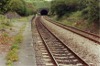
 bpm01425.jpg |
SWM | Severn Tunnel Jct & Fishguard Harbour | Looking towards Gowerton from the summit of the South Wales Main line between Swansea and Gowerton from a point just west of the former Cockett station | Cockett summit | 216 | 77 | SE | 02-Jun-90 | 16.52 |
 bpm01426.jpg |
SWM | Severn Tunnel Jct & Fishguard Harbour | Looking east towards Cockett summit from a point north-west of the former Cockett station | West of Cockett summit | 217 | 00.5 | West | 02-Jun-90 | 16.55 |
 bpm01427.jpg |
SWM | Severn Tunnel Jct & Fishguard Harbour | I.K. Brunel's embankment stabilising arches, east of Cockett tunnel | East side of Cockett tunnel | 216 | 26 | NW | 02-Jun-90 | 17.15 |
 bpm01428.jpg |
SWM | Severn Tunnel Jct & Fishguard Harbour | I.K.Brunel's embankment restraining arches and east portal of 789-yard Cockett tunnel | Cockett tunnel, south-east end | 216 | 25 | SE | 02-Jun-90 | 17.19 |
 bpm01429.jpg |
SWM | Severn Tunnel Jct & Fishguard Harbour | Looking east down Cwmbwrla bank towards Swansea | Unclassified road overbridge, south-east side of Cockett tunnel | 216 | 19 | NW | 02-Jun-90 | 17.23 |
 bpm01430.jpg |
VON | Neath (General) & Pontypool Rd | The headshunt for the Tower colliery coal loading traffic. This curtailed VON line is located east of the former Rhigos halt where an industrial estate is now established | Former station near Tower Colliery (Hirwaun Pond) | 27 | 14 | West | 03-Jun-90 | 15.54 |
 bpm01431.jpg |
VON | Neath (General) & Pontypool Rd | The former Hirwaun Pond station site now serving as a run-around facility for Tower colliery traffic. The headshunt at the end of the platforms marks the curtailment of the former Vale of Neath line from the Aberdare side. | Tower Colliery railhead (run-around facility) | 27 | 00 | SE | 03-Jun-90 | 16.01 |
 bpm01432.jpg |
VON | Neath (General) & Pontypool Rd | The Tower colliery coal loading site between Rhigos and Hirwaun | Tower Colliery railhead | 27 | 00 | SW | 03-Jun-90 | 16.03 |
 bpm01433.jpg |
VON | Neath (General) & Pontypool Rd | The headshunt buffer stop at the Aberdare side of the curtailed Vale of Neath line, marking the end of the line for Tower colliery traffic | Tower Colliery railhead (Former station, Hirwaun Pond) | 27 | 12 | SE | 03-Jun-90 | 16.11 |
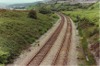
 bpm01434.jpg |
VON | Neath (General) & Pontypool Rd | The singled former double line Vale of Neath branch just east of Gelli Tarw junction between Aberdare and Hirwaun | Incline approaching former Gelli Tarw junction | 24 | 37 | NW | 03-Jun-90 | 16.40 |
 bpm01435.jpg |
VON | Neath (General) & Pontypool Rd | The singled former double line Vale of Neath branch just east of Gelli Tarw junction between Aberdare and Hirwaun. The former Merthyr branch ran from the junction at the summit and along the level seen at the right of the cutting | Incline approaching former Gelli Tarw junction | 24 | 45 | SE | 03-Jun-90 | 16.47 |
 bpm01436.jpg |
MER | Merthyr & Gelli Tarw junction | The former sidings area of the Merthyr branch at Gelli Tarw junction. Sleeper indentations are still visible | Trackbed / exchange sidings, former Gelli Tarw junction | 0 | 06 | West | 03-Jun-90 | 16.47 |
 bpm01437.jpg |
MER | Merthyr & Gelli Tarw junction | Looking towards Gelli tarw junction site from the lifted sidings area of the Merthyr branch. The Vale of Neath single line to Tower colliery is just visible on the left | Trackbed / exchange sidings, former Gelli Tarw junction | 0 | 06 | East | 03-Jun-90 | 16.47 |
 bpm01438.jpg |
VON | Neath (General) & Pontypool Rd | Gelli Tarw junction site at the summit of the incline from Aberdare, with the former Merthyr branch formation on the left and running straight ahead on the level. Much earlier, the Dare branch also ran to the right from a point 3 chains to the rear of camera but was closed in 1935 | Former Gelli Tarw junction | 24 | 60 | West | 03-Jun-90 | 16.50 |
 bpm01439.jpg |
VON | Neath (General) & Pontypool Rd | Looking towards Hirwaun from a point west of the former Gelli Tarw junction | West of former Gelli Tarw junction | 24 | 66 | East | 03-Jun-90 | 16.53 |
 bpm01440.jpg |
VON | Neath (General) & Pontypool Rd | Looking towards Aberdare from the approximate site of the original junction with the Dare branch which ran to the right but was closed in 1935 | West of former Gelli Tarw junction | 24 | 66 | West | 03-Jun-90 | 16.53 |
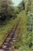
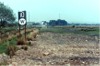 bpm01441.jpg |
NAB | Neath & Brecon junction & Colbren junction | View of speed restriction and inclusive" Whistle" board still in place at lifted section of track west of Onllwyn Washery and preceding road level crossing on Colbren to Glyn Neath Road (A4109). Colbren junction and station was located in the vicinity of the pine trees in the distance. | West of Onllwyn Washery | ~10 | 68 | SW | 20-May-89 | 14.12 |
 bpm01442.jpg |
NAB | Neath & Brecon junction & Colbren junction | Looking south-east towards the former Blaenant colliery from the A4109 road underbridge, south of Crynant | Ynysyderw Rd underbridge (A4109) north of former Blaenant Colliery | 4 | 67.25 | NE | 24-Jun-89 | 15.00 |
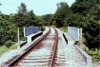 bpm01443.jpg |
NAB | Neath & Brecon junction & Colbren junction | Looking north-east towards Crynant showing the slightly skewed single line bridge over the A4109 road | Ynysyderw Rd underbridge (A4109) north of former Blaenant Colliery | 4 | 67.25 | SW | 24-Jun-89 | 15.00 |
 bpm01444.jpg |
NAB | Neath & Brecon junction & Colbren junction | Looking south-west from a point south of the former Crynant station site | Brynawel road underbridge south of former Crynant Station | 5 | 27 | NE | 24-Jun-89 | 15.07 |
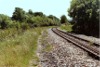
 bpm01445.jpg |
NAB | Neath & Brecon junction & Colbren junction | Looking north-east towards the site of the former Crynant station. The rail overbridge originally carried three tracks here and previously, siding connections served three collieries in the area. Note the expansion "breather" in the track | Brynawel road underbridge south of former Crynant Station | 5 | 27 | South | 24-Jun-89 | 15.07 |
 bpm01446.jpg |
NAB | Neath & Brecon junction & Colbren junction | Looking south-west at the then, recently reballasted curve in the single track, south of the former Seven Sisters station | Commercial St overbridge south of former Seven Sisters Station | 7 | 48.5 | NE | 24-Jun-89 | 15.17 |
 bpm01447.jpg |
NAB | Neath & Brecon junction & Colbren junction | Looking north east from Commercial st overbridge south of the former Seven Sisters station, the cut back platform of which are visible in the distance | Commercial St overbridge south of former Seven Sisters Station | 7 | 49 | SW | 24-Jun-89 | 15.17 |
 bpm01448.jpg |
NAB | Neath & Brecon junction & Colbren junction | Looking south-west from a footbridge north-east of the former Pantyffordd halt site and north-east of Seven Sisters | Footbridge over track from Golwg-y-bryn road (A4109) between Onllywn Washery & Seven Sisters | 9 | 55 | NE | 24-Jun-89 | 15.23 |
 bpm01449.jpg |
NAB | Neath & Brecon junction & Colbren junction | Looking north-east from a footbridge north-east of the former Pantyffordd halt site. The "End of Token Section" board is visible, left of track | Footbridge 5 chains south of "End of token section" board (7 chains south of Onllwyn loop) | 9 | 55 | South | 24-Jun-89 | 15.23 |
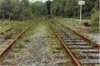
 bpm01450.jpg |
- | British Coal Onllwyn Washery private sidings | Sidings west of Onllwyn Washery as seen from an unclassified road overberidge, east of the former Onllwyn signal box and station site. These sidings are now lifted | North end of Onllwyn loop adjacent to former N&B station | 10 | 26 | East | 24-Jun-89 | 15.25 |
|
Photos 1401-1450 |
|||||||||
|
Date Last Revised:November 25, 2009 |
|||||||||